Friday, April 7, 2017

Climate

Most of Massachusetts has a humid continental, with cold winters and warm summers. Far southeast coastal areas are the broad transition zone to temperate climates (humid subtropical climate in some classifications). The warm to hot summers render the oceanic climate rare in this transition, only applying to exposed coastal areas such as on the peninsula of Barnstable County. The climate of Boston is quite representative for the commonwealth, characterized by summer highs of around 81 °F (27 °C) and winter highs of 35 °F (2 °C), and is quite wet. Frosts are frequent all winter, even in coastal areas due to prevailing inland winds. Due to its location near the Atlantic, Massachusetts is vulnerable to hurricanes and tropical storms.
Average daily maximum and minimum temperatures for selected cities in Massachusetts[148]
Location July (°F) July (°C) January (°F) January (°C)
Boston 81/65 27/18 36/22 2/–5
Worcester 79/61 26/16 31/17 0/–8
Springfield 84/62 27/17 34/17 1/–8
New Bedford 80/65 26/18 37/23 3/–4
Quincy 80/61 26/16 33/18 1/–7
Plymouth 80/61 27/16 38/20 3/–6

Demographics

Massachusetts population density map. The centers of high-density settlement, from east to west, are Boston, Worcester, Springfield, and Pittsfield, respectively.
Historical population
Census Pop.
1790 378,787
1800 422,845
11.6%
1810 472,040
11.6%
1820 523,287
10.9%
1830 610,408
16.6%
1840 737,699
20.9%
1850 994,514
34.8%
1860 1,231,066
23.8%
1870 1,457,351
18.4%
1880 1,783,085
22.4%
1890 2,238,947
25.6%
1900 2,805,346
25.3%
1910 3,366,416
20.0%
1920 3,852,356
14.4%
1930 4,249,614
10.3%
1940 4,316,721
1.6%
1950 4,690,514
8.7%
1960 5,148,578
9.8%
1970 5,689,170
10.5%
1980 5,737,037
0.8%
1990 6,016,425
4.9%
2000 6,349,097
5.5%
2010 6,547,629
3.1%
Est. 2016 6,811,779
4.0%
[7][149][150][151]
The United States Census Bureau estimated that the population of Massachusetts was 6,794,422 on July 1, 2015, a 3.77% increase since the 2010 United States Census.[7]
As of 2014, Massachusetts was estimated to be the third most densely populated U.S. state, with 839.4 people per square mile,[7] behind New Jersey and Rhode Island. In 2014, Massachusetts had 1,011,811 foreign-born residents or 15% of the population.[7]
Most Bay State residents live within the Boston Metropolitan Area, also known as Greater Boston, which includes Boston and its proximate surroundings but also extending to Greater Lowell and to Worcester. The Springfield metropolitan area, also known as Greater Springfield, is also a major center of population. Demographically, the center of population of Massachusetts is located in the town of Natick.[152][153]
Like the rest of the northeastern United States, the population of Massachusetts has continued to grow in the past few decades. Massachusetts is the fastest growing state in New England and the 25th fastest growing state in the United States.[154] Population growth was largely due to a relatively high quality of life and a large higher education system in the state.[154]
Foreign immigration is also a factor in the state's population growth, causing the state's population to continue to grow as of the 2010 Census (particularly in Massachusetts gateway cities where costs of living are lower).[155][156] 40% of foreign immigrants were from Central or South America, according to a 2005 Census Bureau study, with many of the remainder from Asia. Many residents who have settled in Greater Springfield claim Puerto Rican descent.[155] Many areas of Massachusetts showed relatively stable population trends between 2000 and 2010.[156] Exurban Boston and coastal areas grew the most rapidly, while Berkshire County in far Western Massachusetts and Barnstable County on Cape Cod were the only counties to lose population as of the 2010 Census.[156]
By gender, 48.4% were male and 51.6% were female in 2014. In terms of age, 79.2% were over 18 years old and 14.8% were over 65 years old.[7]

Ecology

Ecology

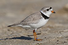
Many coastal areas in Massachusetts provide breeding areas for species such as the piping plover.
The primary biome of inland Massachusetts is temperate deciduous forest.[136] Although much of Massachusetts had been cleared for agriculture, leaving only traces of old-growth forest in isolated pockets, secondary growth has regenerated in many rural areas as farms have been abandoned.[137] Currently, forests cover around 62% of Massachusetts.[138] The areas most affected by human development include the Greater Boston area in the east and the Springfield metropolitan area in the west, although the latter includes agricultural areas throughout the Connecticut River Valley.[139] There are currently 219 endangered species in Massachusetts.[140]
A number of species are doing well in the increasingly urbanized Massachusetts. Peregrine falcons utilize office towers in larger cities as nesting areas,[141] and the population of coyotes, whose diet may include garbage and roadkill, has been increasing in recent decades.[142] White-tailed deer, raccoons, wild turkeys, and eastern gray squirrels are also found throughout Massachusetts. In more rural areas in the western part of Massachusetts, larger mammals such as moose and black bears have returned, largely due to reforestation following the regional decline in agriculture.[143]
Massachusetts is located along the Atlantic Flyway, a major route for migratory waterfowl along the eastern coast.[144] Lakes in central Massachusetts provide habitat for many species of fish and waterfowl, but some species such as the common loon are becoming rare.[145] A significant population of long-tailed ducks winter off Nantucket. Small offshore islands and beaches are home to roseate terns and are important breeding areas for the locally threatened piping plover.[146] Protected areas such as the Monomoy National Wildlife Refuge provide critical breeding habitat for shorebirds and a variety of marine wildlife including a large population of grey seals.
Freshwater fish species in Massachusetts include bass, carp, catfish, and trout, while saltwater species such as Atlantic cod, haddock, and American lobster populate offshore waters.[147] Other marine species include Harbor seals, the endangered North Atlantic right whales, as well as humpback whales, fin whales, minke whales, and Atlantic white-sided dolphins.

Geography

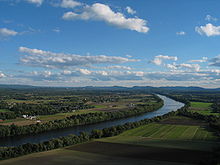
A portion of the north-central Pioneer Valley in Sunderland
Massachusetts is the 7th smallest state in the United States. It is located in the New England region of the northeastern United States, and has an area of 10,555 square miles (27,340 km2), 25.7% of which is water. Several large bays distinctly shape its coast. Boston is the largest city, at the inmost point of Massachusetts Bay, and the mouth of the Charles River.
Despite its small size, Massachusetts features numerous topographically distinctive regions. The large coastal plain of the Atlantic Ocean in the eastern section of the state contains Greater Boston, along with most of the state's population,[42] as well as the distinctive Cape Cod peninsula. To the west lies the hilly, rural region of Central Massachusetts, and beyond that, the Connecticut River Valley. Along the western border of Western Massachusetts lies the highest elevated part of the state, the Berkshires.
The U.S. National Park Service administers a number of natural and historical sites in Massachusetts.[134] Along with twelve national historic sites, areas, and corridors, the National Park Service also manages the Cape Cod National Seashore and the Boston Harbor Islands National Recreation Area.[134] In addition, the Department of Conservation and Recreation maintains a number of parks, trails, and beaches throughout Massachusetts.[135]

20th century

With the exodus of several manufacturing companies, the area's industrial economy began to decline during the early 20th century. By the 1920s, competition from the South and Midwest, followed by the Great Depression, led to the collapse of the three main industries in Massachusetts: textiles, shoemaking, and precision mechanics.[119] This decline would continue into the later half of the century; between 1950 and 1979, the number of Massachusetts residents involved in textile manufacturing declined from 264,000 to 63,000.[120] The 1969 closure of the Springfield Armory, in particular, spurred an exodus of high-paying jobs from Western Massachusetts, which suffered greatly as it de-industrialized during the last 40 years of the 20th century.[121]
Massachusetts manufactured 3.4 percent of total United States military armaments produced during World War II, ranking tenth among the 48 states.[122] In Eastern Massachusetts, following World War II, the economy was transformed from one based on heavy industry into a service-based economy.[123] Government contracts, private investment, and research facilities led to a new and improved industrial climate, with reduced unemployment and increased per capita income. Suburbanization flourished, and by the 1970s, the Route 128 corridor was dotted with high-technology companies who recruited graduates of the area's many elite institutions of higher education.[124]
Kennedy brothers John, Robert (middle) and Edward in July 1960.
The Kennedy family was prominent in Massachusetts politics in the 20th century. Children of businessman and ambassador Joseph P. Kennedy Sr. included John F. Kennedy, who was a senator and US president before his assassination in 1963, Robert F. Kennedy, who was a senator, US attorney general, and presidential candidate before his assassination in 1968, Ted Kennedy, a senator from 1962 until his death in 2009,[125] and Eunice Kennedy Shriver, a co-founder of the Special Olympics.[126] In 1966, Massachusetts became the first state to popularly elect an African American to the US senate with Edward Brooke.[127] George H. W. Bush, 41st President of the United States (1989–1993) was born in Milton in 1924.[128]
In 1987, the state received federal funding for the Central Artery/Tunnel Project. Commonly known as "the Big Dig", it was, at the time, the biggest federal highway project ever approved.[129] The project included making the Central Artery a tunnel under downtown Boston, in addition to the re-routing of several other major highways.[130] Often controversial, with numerous claims of graft and mismanagement, and with its initial price tag of $2.5 billion increasing to a final tally of over $15 billion, the Big Dig has nonetheless changed the face of Downtown Boston.[129] It has connected areas that were once divided by elevated highway (much of the raised old Central Artery was replaced with the Rose Fitzgerald Kennedy Greenway), and improved traffic conditions along a number of routes.[129][130] Additionally, Massachusetts has had a diplomatic relationship with the Japanese prefecture of Hokkaido since 1988.[131]

21st century

On May 17, 2004, Massachusetts became the first state in the U.S. to legalize same-sex marriage after a Massachusetts Supreme Judicial Court ruling in November 2003 determined that the exclusion of same-sex couples from the right to a civil marriage was unconstitutional.[57] This decision was eventually superseded by the U.S. Supreme Court's affirmation of same-sex marriage in the United States in 2015.
Boston Marathon bombing
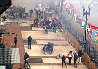
Two pressure cooker bombs exploded near the finish line of the Boston Marathon on April 15, 2013 at around 2:49 pm EDT. The explosions killed three civilians and injured an estimated 264 others. The Federal Bureau of Investigation (FBI) later identified the suspects as brothers Dzhokhar Tsarnaev and Tamerlan Tsarnaev. The ensuing manhunt ended on April 19 when thousands of law enforcement officers searched a 20-block area of nearby Watertown. Dzhokhar later said that he was motivated by extremist Islamic beliefs and learned to build explosive devices from an Inspire, the online magazine of al-Qaeda in the Arabian Peninsula.
On November 8, 2016, Massachusetts voted in favor of The Massachusetts Marijuana Legalization Initiative, also known as Question 4.[132] It was included on the United States presidential election, 2016 ballot in Massachusetts as an indirect initiated state statute.[133]

Geography

19th century

In 1820, Maine separated from Massachusetts and entered the Union as the 23rd state as a result of the ratification of the Missouri Compromise.[106]
Textile mills such as the Boott Mills in Lowell made Massachusetts a leader in the Industrial Revolution in the United States.
During the 19th century, Massachusetts became a national leader in the American Industrial Revolution, with factories around cities such as Lowell and Boston producing textiles and shoes, and factories around Springfield producing tools, paper, and textiles.[107][108] The economy transformed from one based primarily on agriculture to an industrial one, initially making use of water-power and later the steam engine to power factories. Canals and railroads were used for transporting raw materials and finished goods.[109] At first, the new industries drew labor from Yankees on nearby subsistence farms, and later relied upon immigrant labor from Europe and Canada.[110][111]
In the years leading up to the American Civil War, Massachusetts was a center of progressivist and abolitionist activity. Horace Mann made the state's school system a national model.[112] Henry David Thoreau and Ralph Waldo Emerson made major contributions to American philosophy.[113] Members of the transcendentalist movement emphasized the importance of the natural world and emotion to humanity.[113]
Although significant opposition to abolitionism existed early on in Massachusetts, resulting in anti-abolitionist riots between 1835 and 1837,[114] opposition to slavery gradually increased throughout the next few decades.[115][116] Abolitionists John Brown and Sojourner Truth lived in Springfield and Northampton, respectively, while Frederick Douglass lived in Boston and Susan B. Anthony in Adams, Massachusetts. The works of such abolitionists contributed to Massachusetts' actions during the Civil War. Massachusetts was the first state to recruit, train, and arm a Black regiment with White officers, the 54th Massachusetts Infantry Regiment.[117] In 1852, Massachusetts became the first state to pass compulsory education laws.[118]
Alexander Graham Bell is commonly credited as the inventor of the first practical telephone. On March 10, 1876 at Boston University, he was able to communicate with his assistant Thomas A. Watson in the next room.

Federal period

Bostonian John Adams, known as the "Atlas of Independence",[101] was an important figure in both the struggle for independence as well as the formation of the new United States. Adams was highly involved in the push for separation from Britain and the writing of the Constitution of Massachusetts in 1780 which, in the Elizabeth Freeman and Quock Walker cases, effectively made Massachusetts the first state to have a constitution that declared universal rights and, as interpreted by Supreme Judicial Court Chief Justice William Cushing, abolished slavery. David McCullough points out that an equally important feature was its placing for the first time the courts as a co-equal branch separate from the executive.[102] The Constitution of Vermont, adopted in 1777, represented the first partial ban on slavery. Vermont became a state in 1791, but did not fully ban slavery until 1858 with the Vermont Personal Liberty Law. The Pennsylvania Gradual Abolition Act of 1780[103] made Pennsylvania the first state to abolish slavery by statute. Later, Adams was active in early American foreign affairs and succeeded Washington as the second United States President. His son John Quincy Adams, also from Massachusetts,[104] would go on to become the sixth United States President.
From 1786 to 1787, an armed uprising, known as Shays' Rebellion led by Revolutionary War veteran Daniel Shays wrought havoc throughout Massachusetts, and ultimately attempted to seize the Federal armory.[49] The rebellion was one of the major factors in the decision to draft a stronger national constitution to replace the Articles of Confederation.[49] On February 6, 1788, Massachusetts became the sixth state to ratify the United States Constitution.[105]

The Revolutionary War

The Revolutionary War

Earl, Ralph; Doolittle, Amos (1775). "Percy's Rescue at Lexington" (illustration)., about the Battles of Lexington and Concord
Massachusetts was a center of the movement for independence from Great Britain; colonists in Massachusetts had long uneasy relations with the British monarchy, including open rebellion under the Dominion of New England in the 1680s.[90] Protests against British attempts to tax the colonies after the French and Indian War ended in 1763 led to the Boston Massacre in 1770, and the 1773 Boston Tea Party escalated tensions.[94] In 1774, the Intolerable Acts targeted Massachusetts with punishments for the Boston Tea Party and further decreased local autonomy, increasing local dissent.[95] Anti-Parliamentary activity by men such as Samuel Adams and John Hancock, followed by reprisals by the British government, were a primary reason for the unity of the Thirteen Colonies and the outbreak of the American Revolution in 1775.[96]
The Battles of Lexington and Concord initiated the American Revolutionary War and were fought in the eponymous Massachusetts towns.[97] Future President George Washington took over what would become the Continental Army after the battle. His first victory was the Siege of Boston in the winter of 1775–76, after which the British were forced to evacuate the city.[98] The event is still celebrated in Suffolk County as Evacuation Day.[99] On the coast, Salem became a center for privateering. Although the documentation is incomplete, about 1700 letterss of marque, issued on a per-voyage basis, were granted during the American Revolution. Nearly 800 vessels were commissioned as privateers and are credited with capturing or destroying about 600 British ships.[100]

Federal period