Main articles: Geography of Massachusetts and Geology of New England
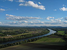
A portion of the north-central Pioneer Valley in Sunderland
Despite its small size, Massachusetts features numerous topographically distinctive regions. The large coastal plain of the Atlantic Ocean in the eastern section of the state contains Greater Boston, along with most of the state's population,[42] as well as the distinctive Cape Cod peninsula. To the west lies the hilly, rural region of Central Massachusetts, and beyond that, the Connecticut River Valley. Along the western border of Western Massachusetts lies the highest elevated part of the state, the Berkshires.
The U.S. National Park Service administers a number of natural and historical sites in Massachusetts.[134] Along with twelve national historic sites, areas, and corridors, the National Park Service also manages the Cape Cod National Seashore and the Boston Harbor Islands National Recreation Area.[134] In addition, the Department of Conservation and Recreation maintains a number of parks, trails, and beaches throughout Massachusetts.[135]

No comments:
Post a Comment